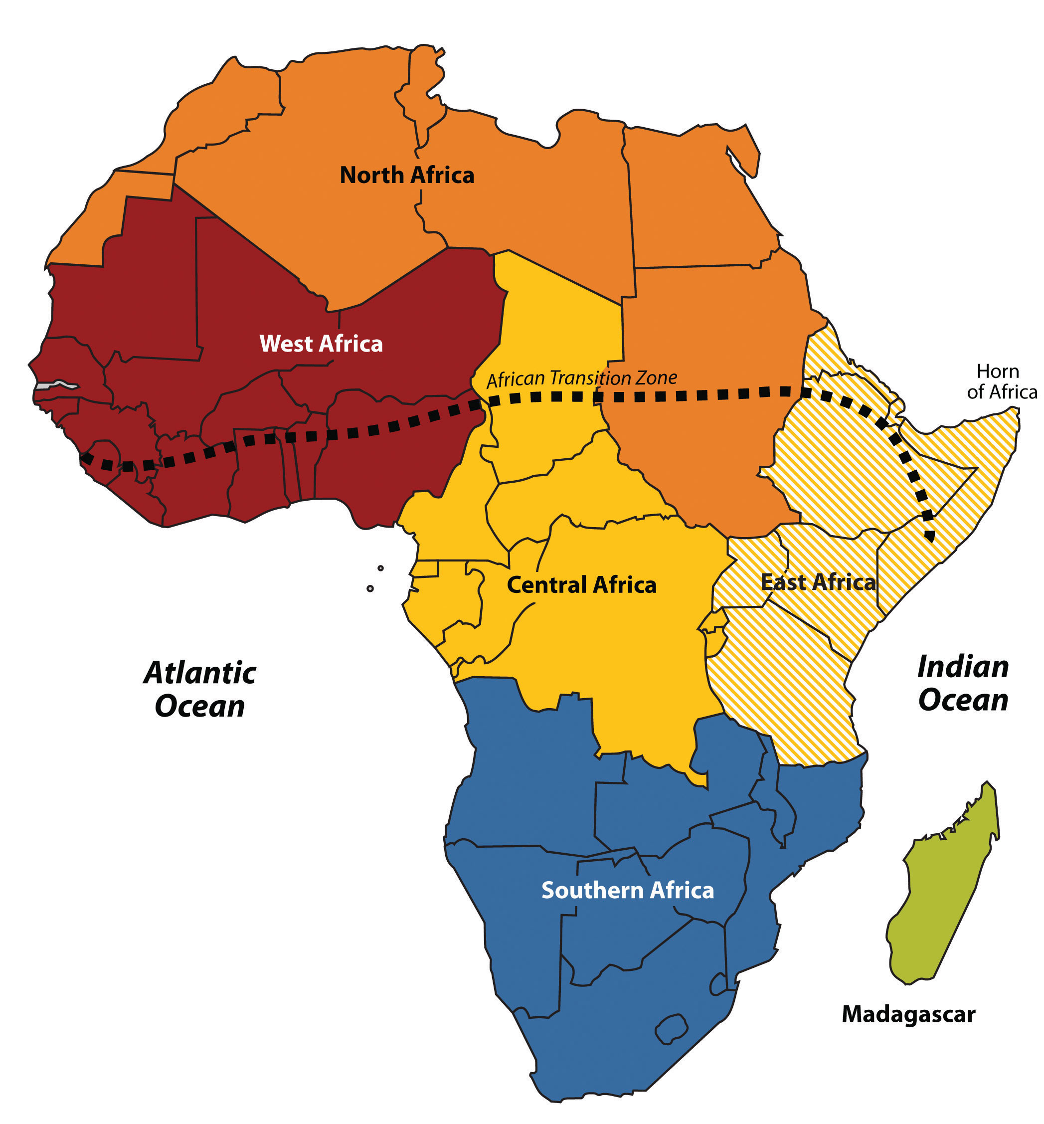
African Transition Zone
The African Transition Zone divides North Africa from the rest of Africa because of climatic and cultural dynamics. Cultural conflicts and desertification are frequent in the zone. Dry, arid type B climates, common in the Sahara Desert, are dominant north of the zone. Tropical type A climates prevail south of the zone. Global climate changes continue to shape the continent. The shifting sands of the Sahara are slowly moving southward toward the tropics. Desertification in the zone continues as natural conditions and human activity place pressure on the region through overgrazing and the lack of precipitation. Type B climates resurface again south of the tropics in the southern latitudes. The Kalahari and Namib Deserts are located in Southern Africa, mainly in the countries of Botswana and Namibia.
Physical Landscape
For a continent as vast as Africa, Subsaharan Africa does not have extended mountain ranges comparable to the ranges in North or South America, Europe, Asia, or Antarctica. There are, however, on the Ethiopian Highlands, the Ethiopian Plateau that reaches as high as 15,000 feet in elevation. East Africa has several well-known volcanic peaks that are high in elevation. The tallest point in Africa, Mt. Kilimanjaro in Tanzania near the border with Kenya, is 19,340 feet high. Nearby in Kenya, Mt. Kenya is 17,058 feet high. The Rwenzori Mountains on The Congo/Uganda border reach more than 16,000 feet in elevation and create a rain shadow effect for the region. Permanent glaciers exist on these ranges even though they are near the equator. On the western side of the continent, Mt. Cameroon in Central Africa is more than 13,000 feet in elevation. South Africa’s Cape Ranges are low-lying mountains no higher than about 6,000 feet. The continent of Africa consists of basins and plateaus without long mountain chains. The plateaus can range more than 1,000–2,500 feet in elevation. The only continuous feature is the eastern rift valleys that run along the tectonic plate boundaries from the Red Sea through to South Africa.
The main rivers of Africa include the Nile, Niger, Congo, and the Zambezi. The Nile River competes with the Amazon for the status as the longest river in the world; the White Nile branch begins in Lake Victoria in East Africa, and the Blue Nile branch starts in Lake Tana in Ethiopia. The Niger flows through West Africa; its mouth is in Nigeria. The Congo River crosses the equator with a large tropical drainage basin that creates a flow of water second only to the Amazon in volume. The Zambezi River in the south is famous for the extensive Victoria Falls on the Zambia and Zimbabwe border. Victoria Falls is considered the largest waterfall in the world. Other significant rivers exist such as the Orange River, which makes up part of the border between South Africa and Namibia.
There are a number of large lakes in Subsaharan Africa. The largest is Lake Victoria, which borders several East African countries and is considered to be the second-largest lake in the world in surface area. Only Lake Superior in North America has a greater surface area. A number of large lakes are located in the rift valleys of the east. Three of the largest lakes along the western rift are Lake Malawi, Lake Tanganyika, and Lake Albert. To the northeast of these in Kenya is Lake Turkana, which reaches to the Ethiopian border. Lake Chad is located in the African Transition Zone on the border between Chad, Mali, and Nigeria. Lake Chad has been severely reduced in size in recent years.
Climate
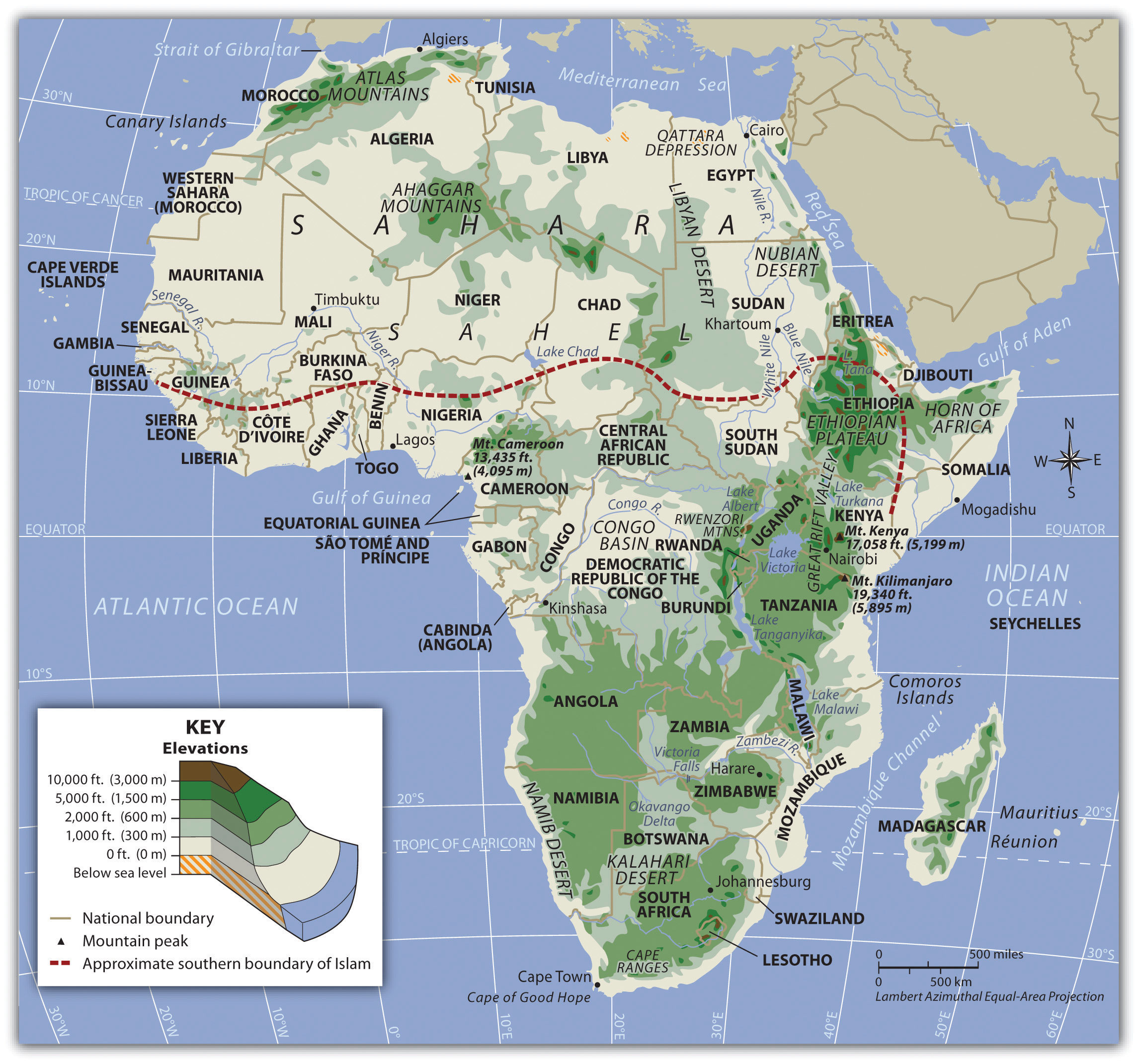
The equator runs through the center of Subsaharan Africa, providing tropical type A climates. These regions usually have more rainfall, resulting in lighter, leached-out soils that may not be as productive as regions with more fertile volcanic soils, such as those found in the rift valleys. Root crops are conventional in Africa, as are millet and corn (maize). The savanna regions of the east and south have seasonal rains that affect the growing season. Soils in savanna areas are usually not as productive and cannot be depended on to fulfill the agricultural needs of growing populations. Savannas are usually grasslands or scrub forests with a seasonal precipitation pattern. Cattle and livestock grazing are common in savannas, and migrations are frequent to follow seasonal grazing conditions. In specific areas of Southern Africa, larger farming operations exist in type C climates. However, Subsaharan Africa is not blessed with the vast regions of fertile alluvial soils found in the Northern Hemisphere. The ever-growing agrarian population has always depended on the land for food and sustenance, but these conditions are not favorable for Africa’s future. Populations are growing faster than any increase in agricultural production.
Increasing populations in Subsaharan Africa are taxing the natural environment. Where the carrying capacity has been exceeded, the natural capital is being depleted at an unsustainable rate. Deforestation is occurring in areas where firewood is in high demand, and trees are cut down faster than they can grow back. Expanding human populations are also encroaching on the natural biodiversity for which the African continent is renowned. Large game animals such as rhinoceroses, elephants, and lions have been hunted or poached with devastating consequences. The creation of game preserves and national parks has stemmed this tide, but poaching remains a serious problem even in these protected areas. Gorilla and chimpanzee populations have also been stressed by human population growth. Humans are killing these animals for bushmeat, and human activities are reducing their habitats.
Poaching and Conservation
https://www.youtube.com/watch?v=-gwgEPuqKd0
https://www.youtube.com/watch?v=6AZlAR4Qonk
Managing Protected Areas
Story Maps
The following story maps focus on poaching and conservation efforts throughout Africa.
- Transcending Boundaries in Conservation
- Managing Protected Areas
Droughts and Famine
Maps of the Region
The following story maps look at wildlife conservation, famine, sanitation, and civil war across the region.
