European Colonialism
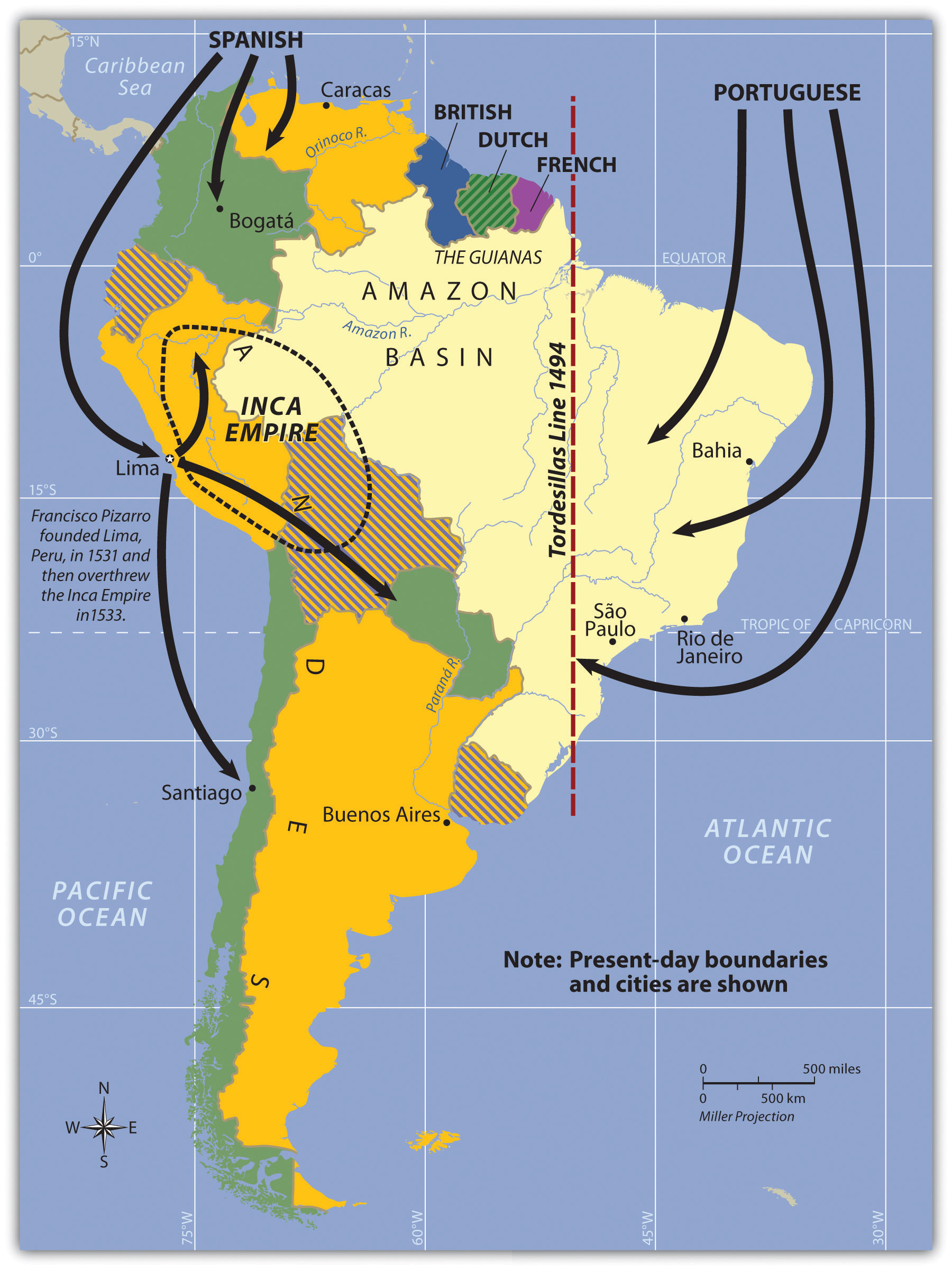
South America’s colonial legacy shaped its early cultural landscape. The indigenous people, with their empires and local groups, were no match for the Iberian invaders who brought European colonialism to the continent. South America was colonized exclusively by two central Iberian powers: Spain colonized the western part of South America, and Portugal colonized the east coast of what is present-day Brazil. The only region that was not colonized by those two powers was the small region of the Guianas, which was colonized by Great Britain, the Netherlands, and France.
 Everything changed with the invasion of the Iberian colonizers. The underlying tenets of culture, religion, and economics of the local indigenous people were disrupted and forced to change. It is no mystery why the two dominant languages of South America are Spanish and Portuguese, and why Roman Catholicism is the realm’s dominant religion. Colonialism also was responsible for transporting food crops such as the potato, which originated in the Peruvian Andes, to the European dinner table. Today, coffee is the main export of Colombia, Brazil, and other countries in the tropics. Coffee was not native to South America but originated in Ethiopia and was transferred by colonial activity. The same is true of sugarcane, bananas, and citrus fruits; oranges were not native to South America, but today, Brazil is the number one exporter of orange juice. Colonialism was driven by the desire for profit from the quick sale of products such as gold or silver, and there was a ready market for goods not found in Europe, such as tobacco, corn, exotic animals, and tropical woods.
Plantation agriculture introduced by the Europeans led to high demand for manual laborers. When the local populations could not meet the labor demand, millions of African workers were brought through the slave trade. These African slaves introduced their unique customs and traditions, altering the culture and demographics of the Western Hemisphere. The current indigenous Amerindian population, a fraction of what it was before the Europeans arrived, makes up only a small percentage of South America’s total population. Europeans colonizers generally took the best land and controlled the economic trade of the region. The acculturation in South America is directly related to the European colonial experience.
The Inca Empire and Francisco Pizarro
Not long after Hernán Cortés conquered the Aztec Empire of Mexico in 1521, a young Spanish conquistador named Francisco Pizarro, stationed in what is now Panama, heard rumors of silver and gold found among the South American people. He led several sailing excursions along the west coast of South America. In 1531 CE, he founded the port city of Lima, Peru. Since 1200 CE, the Inca had ruled a vast empire extending out from central Peru, which included the high-elevation Altiplano Region around Lake Titicaca. The Inca Empire dominated an area from Ecuador to northern Chile. The Inca were not the most populous people but were a ruling class who controlled other subjugated groups. Pizarro, with fewer than two hundred men and two dozen horses, met up with the Inca armies and managed to defeat them in a series of military maneuvers. The Inca leader was captured by the Spanish in 1533. Two years later, in 1535, the Inca Empire collapsed.
 The Inca Empire was significant thanks to the high volume of gold and silver found in that region of the Andes. The story is told that Pizarro placed the captured Inca leader in a small room and told him that if the room were filled with gold to the top of the Inca leader’s head, Pizarro would let the Inca leader go free. Gold was summoned from the people and the countryside, and the room was filled. The conquistadors forced the Inca leader to convert to Catholicism and be baptized and then killed him. The gold was melted down and transported back to Spain. The mineral wealth of the Andes made the conquistadors rich. Lima was once one of the wealthiest cities in the world. Europeans continued to dominate and exploit the mining of minerals in Peru and Bolivia throughout the colonial era. European elites or a Mestizo ruling class has dominated or controlled the local Amerindian groups in the Andes since colonial times.
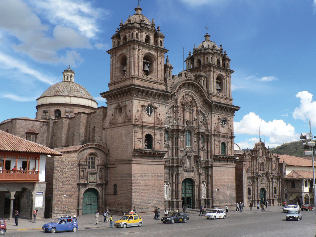
The original church was constructed in 1571 on the site of the ancient Incan palace. The earthquake of 1650 caused severe damage to the building, so it had to be reconstructed in about 1688. Many Catholic cathedrals in Latin America were built with stones from ancient sites. This cathedral is claimed to be the Western Hemisphere’s most ideal example of colonial baroque architecture.
Many Amerindian groups inhabited this region before the Inca Empire, such as the people who built and lived in the ancient city of Tiahuanaco, which could have bordered Lake Titicaca during an earlier climate period, when the lake was much more extensive. Humans have lived in South America for thousands of years. There is speculation that travel between South America and the Mediterranean region occurred earlier than current historical records indicate. Many of the ruins in the western region of South America have not been thoroughly excavated or examined by archaeologists, and the size and scope of many of the stone structures stand as testimony to the advancements in engineering and technology employed in an era that, according to historical records, had only primitive tools.
The Iberian Division of the Continent
The Spanish conquistadors were not the only European invaders to colonize South America. Colonial influence, which forced a change in languages, religion, and economics, also came from the small European kingdom of Portugal. Portuguese ships sailed along the eastern coast of South America and laid claim to the region for the king. The Portuguese did not find large gold or silver reserves, but they coveted the land for the expansion of their empire. Soon the Spanish and the Portuguese were fighting over the same parts of South America. In 1494, the issue was brought before the Roman Catholic Church. The Tordesillas Line was drawn on a map to divide South America into the Spanish west and the Portuguese east. The region that is now Brazil became the most significant Portuguese colonial possession in South Ameri-ca, a center for plantation agriculture similar to that in the Caribbean. For this reason, a large African population lives in Brazil, and most of the people in Brazil speak Portuguese and are Roman Catholics.
Independence did not come for the Spanish colonies until 1816 and 1818, when Chile and Argentina broke away in an independence movement in the south. Simón Bolívar led liberation movements in the north. By 1824, the Spanish were defeated in South America. Brazil did not gain independence from Portugal until 1822, when the prince of Portugal declared an independent Brazil and made himself Brazil’s first emperor. It was not until 1889 that a true republic was declared, and the empire was abolished.
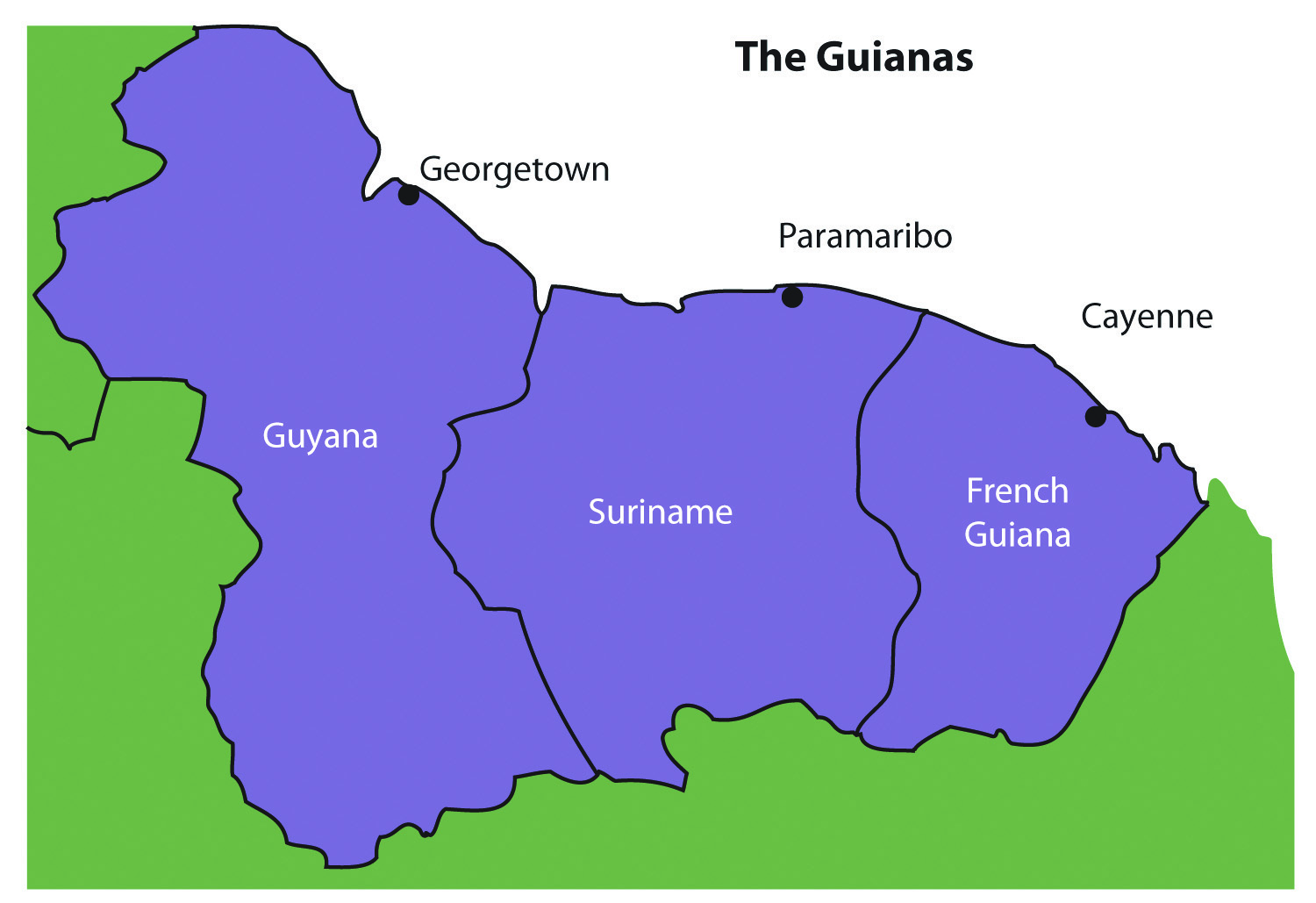
Colonialism and the Guianas
The Guianas in the northeast were the only European colonies in South America that were not under Spanish or Portuguese control. The British, Dutch, and French all held claims to different parts of the Guianas. French Guiana remains a colony (department) of France to this day. The transition from colony to the independent state has required persistence, time, and patience. Guyana and Suriname only just received their independence in the latter part of the twentieth century.
The coastal location of the Guianas provided European colonialists with an excellent site for plantation agriculture. Coastal cities had easy access to the Atlantic trade system. The active slave trade in the Atlantic brought African slaves to the Guianas to work the plantations. When slavery was abolished, indentured servants were brought in from other parts of the world that were colonized by the same European powers. Colonialism and plantation agriculture entirely changed the cultural dynamics of the Guianas. Port cities along the coast are the dominant urban centers. The Guianas follow a pattern like that of the rimland of the Caribbean and are included with the Caribbean in many studies. At present, bauxite (aluminum ore) mining and oil deposits along the coast provide modest income, and many people make their living in subsistence agriculture.
Guyana
Guyana and its neighbors have a tropical type A climate. The central interior regions are covered with dense forests. Some deforestation has taken place in Guyana; even so, forests cover more than 80 percent of Guyana’s land area with a diverse range of forests, ranging from dry evergreen forests to tropical rain forests, and with thousands of species of plants that are only found in this region. Guyana’s natural habitats and biodiversity are unparalleled, which is attributable to the climate, distinctive landforms, and well-preserved ecosystems. Its vast rain forests play host to a myriad of species not found elsewhere. The interior regions remain more than 70 percent pristine, but this will change if logging, mining, and deforestation are not managed appropriately.
Guyana was called British Guiana before it became independent in 1966. The region was home to Carib and Arawak groups before the arrival of the Dutch, who established the first colony there in 1616. By 1831, the British had taken control and declared the colony British Guiana. African slaves were the primary source of plantation labor until slavery was abolished in 1834. At that point, indentured servants from many countries were targeted for labor; most were East Indians from South Asia. There were also thousands of servants from China and other countries.
The ethnic background of Guyana’s population, which is less than one million, is a mix of African (36 percent), East Indian (50 percent), and Amerindian (7 percent). The remainder is mixed and European. The religious background of the East Indians includes both Hindus and Muslims. About 50 percent of the population has converted to Christianity. Ethnic divisions create difficulties in organizing politics and social activities. For example, one political concern is that minority groups with greater economic advantages will dominate the political arena without regard to the wishes of other ethnic groups.
Most of Guyana’s people live in the coastal regions. The almost impenetrable interior has large uninhabited areas with dense tropical forests. To protect its unique biodiversity, large areas have been placed in conservation areas and national parks. More than one million acres have been placed in the Konashen Community-Owned Conservation Area (COCA) to help preserve the natural environment and provide a sustainable economic relationship with local Waiwai people. In a similar effort, the government created the Kaieteur National Park, which features the spectacular Kaieteur Falls, which is about five times higher than Niagara Falls in North America. For its size, the falls have an enormous amount of water volume flowing over its crest. Other areas of Guyana are also being considered for preservation.
Guyana’s economy is based on agricultural activities and the export of extracted natural resources. Sugarcane is the main cash crop, and timber sales are increasing. Fishing is common in coastal areas. Bauxite mining has been the main mining activity, and mining of gold and other minerals has only advanced in recent years. Guyana’s economy is like that of many islands of the Caribbean, a relationship exemplified by its membership in the Caribbean Community (CARICOM). CARICOM’s headquarters is located in Georgetown, the capital of Guyana.
Suriname
Suriname’s colonial name was Dutch Guiana. The name was changed when independence was granted in 1975. The cultural background of the colony is as diverse as its history. Dutch Guiana was divided between British and Dutch colonists. Slavery and plantation agriculture were introduced in the colonial period, and the harsh conditions of slavery caused many slaves to escape the plantations and live in the forests. These runaway slaves, called Maroons, eventually organized into viable independent groups. Peace treaties were finally made with the Maroons to grant them legitimate rights. After slavery was abolished, indentured servants from South Asia and the Dutch East Indies (Indonesia) were conscripted into the colony’s labor base.
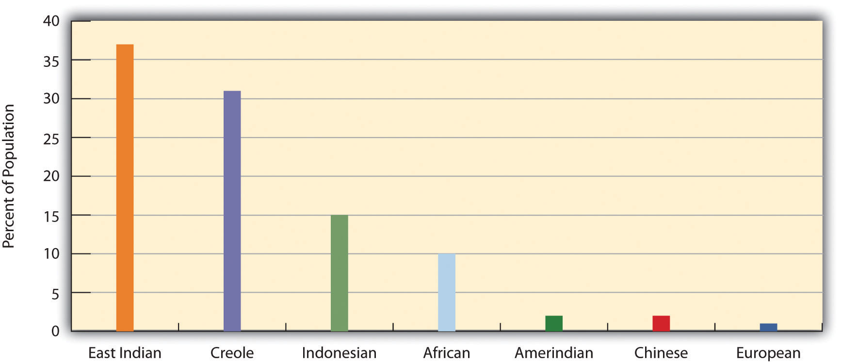
Most of the half-million people who live in Suriname today reside along the coast. The ethnic background of the people includes East Indian (37 percent), Creole (31 percent), Indonesian (15 percent), African (10 percent), Amerindian (2 percent), Chinese (2 percent), and European (about 1 percent). All three of the Guianas are ethnically diverse, and in this setting, diversity creates tensions related to social and economic stability. Guyana and Suriname are the least Latin regions of South America; the Creoles, for example, are mainly a mix of African and Dutch mixed with Asian or Amerindian. Establishing a stable government and conducting civil affairs are often complicated by the ethnic groups that vie for power and political control. The religious background in Suriname includes Hindu, Muslim, Christian, and a mix of African religions such as Winti.
Suriname depends on agriculture and natural resources as its two main economic activities. Suriname has the smallest physical area of all the independent South American states, and it has a limited ability to provide opportunities and advantages for its growing population. Bauxite is the country’s main export product. In 1941, during World War II, the United States occupied the country to secure the valuable bauxite mines that were critical to the war effort. Suriname has also been expanding its gold mining, oil extraction, logging, and fishing industries. To protect the natural environment and extensive biodiversity, the country has established national parks and created the vast Central Suriname Nature Reserve, which UNESCO has named a World Heritage Site. Suriname hopes to benefit from these measures to create an eco-tourism market.
Both Guyana and Suriname have had border disputes with their neighbors. Guyana has been locked in a challenge with Venezuela over its western region, which Venezuela claimed during the colonial era. A 1905 treaty ruled in Guyana’s favor, but a small portion is still under dispute. The corner of Surname that borders Brazil and Guyana has been an issue of contention fueled by the potential for mining of gold and other minerals in the area. The maritime boundary between Suriname and Guyana is also a point of contention. Suriname’s border with French Guiana has a disputed area along the southern corner next to Brazil. These disputes emerged out of colonial agreements and poorly defined treaty boundaries.
French Guiana
French Guiana is still a colony (department) of France. With fewer than 250,000 people in an area slightly smaller than Kentucky, this is a sparsely inhabited area. Half the population lives in the capital city of Cayenne. Most of the population is Creole, mainly a combination of African and French with various Asian groups mixed in. The people work in subsistence agriculture or for the French government. A noted feature of the colony’s heritage is the former off-shore prison on Devil’s Island, which France used to secure its most undesirable prisoners. More than fifty thousand French prisoners were delivered to the Devil’s Island facility during the colonial era, but less than 10 percent survived. The prison was closed in 1951.
The European Space Agency maintains a launch center in French Guiana because of its favorable climate and launch conditions. France maintains the facility and has highly subsidized the department’s economy. This European support provides the population with a higher standard of living than in many other South American countries. Economic activities have included fishing, agriculture (bananas and sugar), and logging. Deforestation from the sale of hardwood lumber has become a problem throughout the Guianas as it leaves the soil open for erosion. Logging endangers the area’s fragile but extensive biodiversity. Roads, dams, and gold mining have also contributed to the erosive destruction of the environment.
Cultural Regions of South America
It is impossible to understand the current conditions in South America without first understanding what occurred to create those conditions. This is why studying European colonialism is essential. Colonialism changed the ethnicity, religion, language, and economic activities of the people in South America. The past five hundred years have tempered, stretched, and molded the current states and regions of the South American continent. To identify standards of living, ethnic majorities, and economic conditions, it is helpful to map out South America’s various cultural regions.
In South America, five central cultural regions indicate the majority of ethnic groups and the main economic activities:
- Tropical Plantation Region
- Rural Amerindian Region
- Amazon Basin
- Mixed Mestizo Region
- European Commercial Region (Southern Cone)
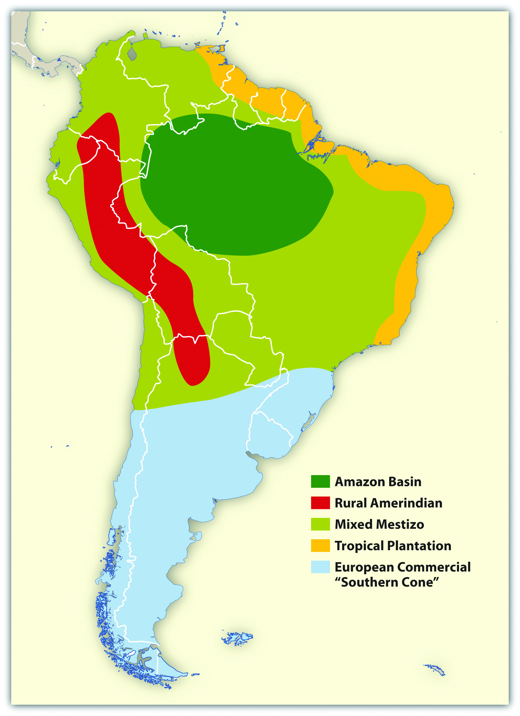
These are generalized regions that provide a basic understanding of the whole continent. Technological advancements and globalization have increased the integration of the continent to the point that these regions are not as delineated as they once were, but they still provide a context in which to comprehend the ethnic and cultural differences that exist within the realm.
Tropical Plantation Region
Located along the north and east coast of South America, the Tropical Plantation Region resembles the Caribbean rimland in its culture and economic activity. The region, which extends as far south as the Tropic of Capricorn, has a tropical climate and an agricultural economy. Europeans opened up this area for plantation agriculture because of coastal access for ships and trade. The local people were forced into slavery, but when the local people died off or escaped, millions of African slaves were brought in to replace them. After slavery was abolished, indentured servants from Asia were brought to the Guianas to work the plantations. The Tropical Plantation Region has a high percentage of people of African or Asian descent.

Rural Amerindian Region
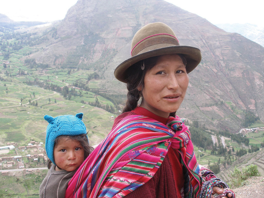
The Rural Amerindian Region includes the countries of Ecuador, Peru, and Bolivia. The ruling Mestizo class that inherited control from the European conquistadors live in urban areas. Most of the rural Amerindian population lives in mountainous areas with type H climates and ekes out a hard living in subsistence agriculture. This is one of the poorest regions of South America, and land and politics are controlled by powerful elites. The extraction of gold and silver has not benefited the local Amerindian majority, which holds to local customs and speaks local languages.
Amazon Basin
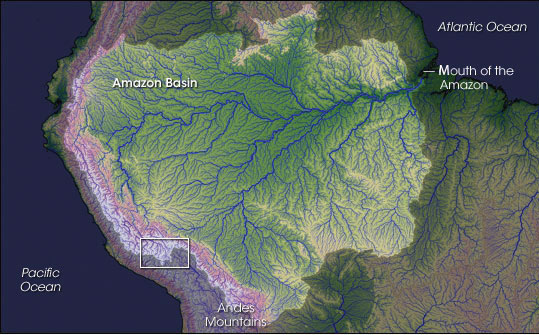
The Amazon Basin, which is characterized by a type A climate, is the least densely populated region of South America and is home to isolated Amerindian groups. Development has encroached upon the region in the forms of deforestation, mining, and cattle ranching. Large deposits of iron ore, along with gold and other minerals, have been found in the Amazon Basin. Preservation of the tropical rain forest of this remote region has been hampered by the destructive pattern of development that has pushed into the region. The future of the basin is unclear because of development patterns that are expected to continue as Brazil seeks to exploit its interior peripheral region. Conflicts over land claims and the autonomy of Amerindian groups are on the rise.
Mixed Mestizo Region
The Mixed Mestizo Region includes the coastal area of the west and the interior highlands of the north and east. This region between the Tropical Plantation Region and the Rural Amerindian Region includes a majority of people who share a mixed European and Amerindian ethnicity. It is not as poor as the Rural Amerindian Region and yet not as wealthy as the European-dominated region to the south. Paraguay falls into the Mixed Mestizo Region, as do other portions of other South American countries such as parts of Brazil, Colombia, and Venezuela. Paraguay is mainly Mestizo, but its economic qualities resemble that of the Rural Amerindian Region to the north, even though Paraguay is not located in the mountains.
European Commercial Region (Southern Cone)
The southern part of South America, called the European Commercial Region or the Southern Cone, includes Chile, Argentina, Uruguay, and parts of Brazil. European ethnic groups dominate this region and include not only Spanish and Portuguese but also German, Austrian, Italian, and other European ethnic heritages. Fertile soils and European trade pro-vided early economic growth, and the region attracted industry and manufacturing in the lat-er decades of the twentieth century. There are not many Amerindians or people of African descent here. More than 90 percent of all the people in Argentina, Chile, and Uruguay are of European descent and live in urban areas. With a highly urbanized population and with trade connections to a globalized economy, it is no surprise that the Southern Cone is home to South America’s most developed economies.
Globalization and Trade
South America has been fragmented by European colonialism, which established colonies and economic dependence on its European masters. The colonial economic patterns did not encourage the South American countries to work together to create an integrated continental trade network. Countries outside the continent have promoted trade partnerships to benefit from South America’s natural resources and agricultural exports. The establishment of the European Union and the North American Free Trade Agreement (NAFTA) created globalized trading blocs that challenged the South American countries to consider how to take advantage of trading opportunities within their realm to protect and support their economic interests.
Since the 1990s, cooperation and business ventures have started to form within the realm to create a more integrated network of trade and commerce to benefit the countries of South America. Transportation and communication systems are being developed through joint ventures by internal investment groups. River and road systems continue to be managed and developed for improved transport of people and goods throughout the continent. Free-trade agreements have been implemented to support the integration of internal economic networks and competition in the global marketplace.
In 2008, the South American countries formed the Union of South American Nations (UNASUR) to oversee the customs unions and trade agreements within the realm. One of the more established trade associations is the Southern Cone Common Market (Mercosur), created in 1995 by the southern countries. It has evolved to include most countries in South America and is the most dominant trade agreement in the realm. Full members of Mercosur include Argentina, Uruguay, Paraguay, and Brazil. Chile, Bolivia, Peru, Ecuador, and Colombia are associate members. As of 2011, Venezuela’s membership was under review. The Andean Community (Colombia, Ecuador, Peru, and Bolivia) was established in 1969 but did not gain ground until 1995, when it established stronger trade measures. Multinational corporations have supported the creation of a Free Trade Area of the Americas (FTAA) to include all of the Western Hemisphere in one unified trade association. It has not been approved and has received strong opposition from Mercosur and economic forces that support a more localized economy controlled by local people.
South America faced division and competition during the colonial era between the Span-ish and the Portuguese. Today’s new era of corporate colonialism has created similar fragmentation and divisions. The level of trade between the countries of South America and the United States and Europe varies widely. Countries such as Colombia and Chile have well-established trade relationships with the United States and are unwilling to jeopardize those trade connections to strengthen ties with their neighbors that have less-supportive political relationships with the United States. External global trade arrangements often provide financial benefits to individual countries that might not be shared by the bordering countries in the same region. South America’s historical fragmentation has not made it easy to unify the continent under a singular trade agreement to compete against the European Union or NAFTA.
