Middle America has various types of physical landscapes, including volcanic islands and mountain ranges. Tectonic action at the edge of the Caribbean Plate has brought about volcanic activity, creating many of the islands of the region as volcanoes rose above the ocean surface. The island of Montserrat is one such example. The volcano on this island has continued to erupt in recent years, showering the island with dust and ash and making habitation difficult. Many of the other low-lying islands, such as the Bahamas, were formed by coral reefs rising above the ocean surface. Tectonic plate activity not only has created volcanic islands but also is a constant source of earthquakes that continue to be a problem for the Caribbean community.
The republics of Central America extend from Mexico to Colombia and form the final connection between North America and South America. The Isthmus of Panama, the narrowest point between the Caribbean Sea and the Pacific Ocean, serves as a land bridge between the continents. The backbone of Central America is mountainous, with many volcanoes located within its ranges. Much of the Caribbean and all of Central America are located south of the Tropic of Cancer and are dominated by tropical type A climates. The mountainous areas have varied climates, with cooler climates located at higher elevations. Mexico has extensive mountainous areas with two main ranges in the north and highlands in the south. There are no landlocked countries in this realm, and coastal areas have been exploited for fishing and tourism development.
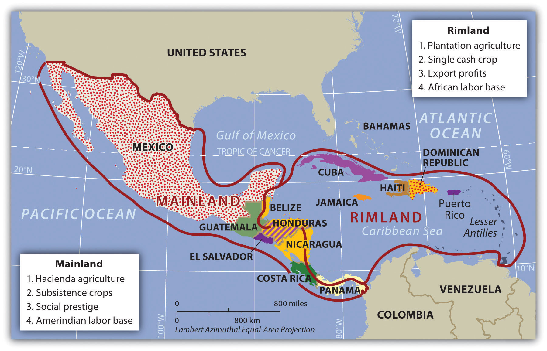
 Rimland and Mainland
Using a regional approach to the geography of a realm helps us compare and contrast a place’s features and characteristics. Location and the physical differences explain the division of Middle America into two geographic areas according to occupational activities and colonial dynamics: the rimland, which includes the Caribbean islands and the Caribbean coastal areas of Central America, and the mainland, which includes the interior of Mexico and Central America.
Colonialism thrived in the rimland because it consists mainly of islands and coastal areas that were accessible to European ships. Ships could smoothly sail into a cove or bay to make port and claim the island for their home country. After an island or coastal area was claimed, there was an unimpeded transformation of the area through plantation agriculture. On a plantation, local individuals were subjugated as servants or slaves. The land was planted with a single crop, usually sugarcane, tobacco, cotton, or fruit, grown for export profits. Most of these crops were not native to the Americas but were brought in during colonial times. European diseases killed vast numbers of local Amerindian laborers, so slaves were brought from Africa to do the work. Plantation agriculture in the rimland was thriving because of the import of technology, slave labor, and raw materials, as well as the export of the harvest to Europe for profit.
Plantation agriculture changed the rimland. The local groups were diminished because of disease and colonial subjugation, and by the 1800s most of the population was of African descent. Native food crops for consumption gave way to cash crops for export. Marginal lands were plowed up and placed into the plantation system. The labor was usually seasonal: there was a high demand for labor at peak planting and harvest times. Plantations were generally owned by wealthy Europeans who may or may not have lived there.
The mainland, consisting of Mexico and the interior of Central America, diverged from the rimland in terms of both colonial dynamics and agricultural production. The interior lacked easy access to the sea that the rimland enjoyed. As a result, the hacienda-style of land use developed. This Spanish innovation was aimed at land acquisition for social prestige and a comfortable lifestyle. Export profits were not the driving force behind the operation, though they may have existed. The indigenous workers, who were poorly paid if at all, were allowed to live on the haciendas, working their plots for subsistence. African slaves were not prominent in the mainland.
In the mainland, European colonialists would enter an area, and stake claims to large portions of the land, often as much as thousands or even in the millions of acres. Haciendas would eventually become the main landholding structure in the mainland of Mexico and many other regions of Middle America. In the hacienda system, the Amerindian people lost ownership of the land to the European colonial masters. Land ownership or the control of land has been a common point of conflict throughout the Americas where land transferred from local indigenous ownership to European colonial ownership.
 The plantation and hacienda eras are in the past. The abolition of slavery in the later 1800s and the cultural revolutions that occurred on the mainland challenged the plantation and hacienda systems and brought about land reform. Plantations were transformed into either multiple private plots or large corporate farms. The hacienda system was broken up, and most of the hacienda land was given back to the people, often in the form of an ejidos system, in which the community owns the land, but individuals can profit from it by sharing its resources. The ejidos system has created its own set of problems, and many of the communally owned lands are being transferred to private owners.
The agricultural systems changed Middle America by altering both the systems of land use and the ethnicity of the population. The Caribbean Basin changed in ethnicity from being entirely Amerindian, to being dominated by European colonizers, to having an African majority population. The mainland experienced the mixing of European culture with the Amerindian culture to form various types of mestizo groups with Hispanic, Latino, or Chicano identities.
Tropical Cyclones (Hurricanes)
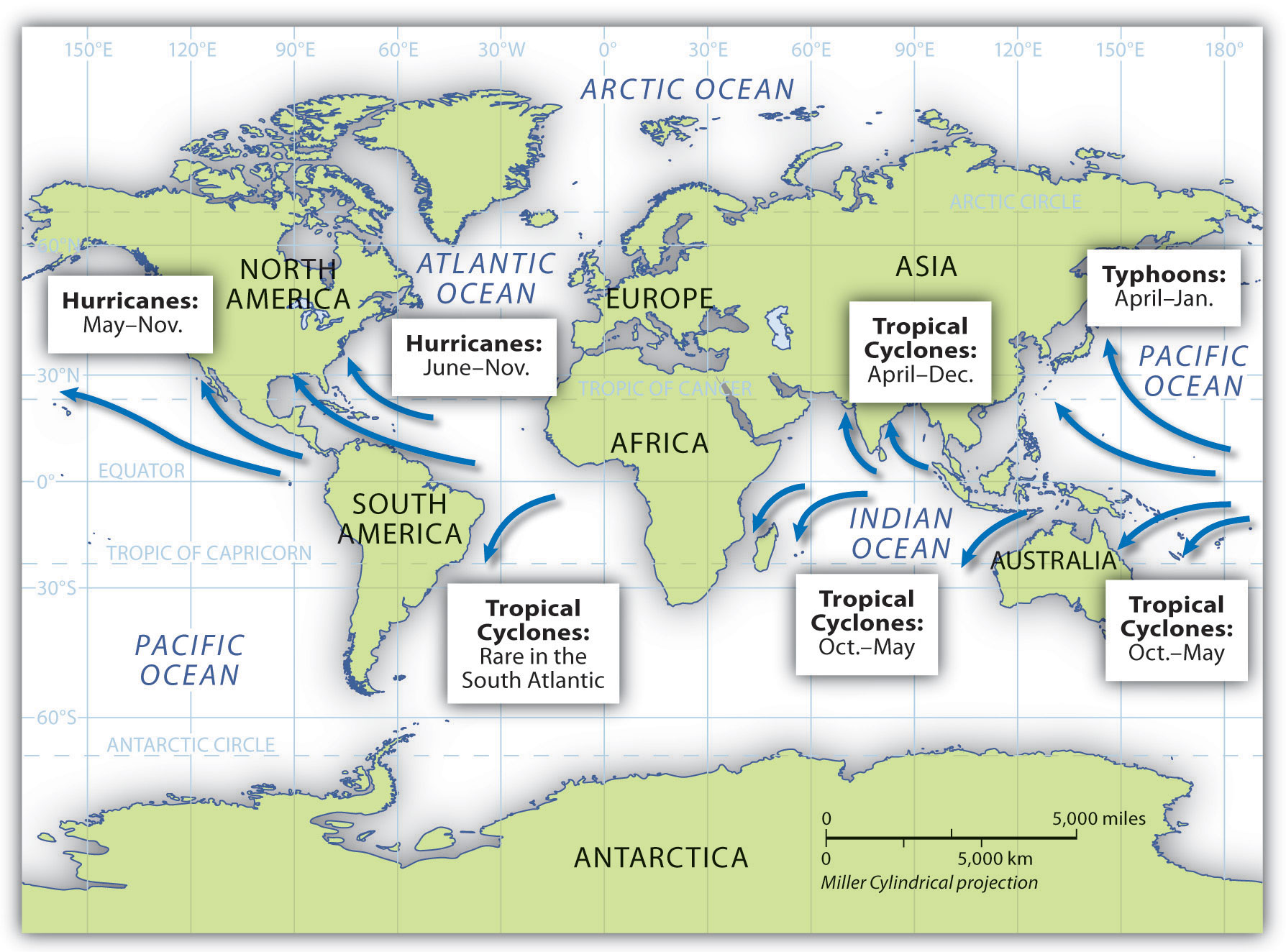
Above the oceans just north and south of the equator, a weather phenomenon called a tropical cyclone can develop that can drastically alter the physical and cultural landscape if it reaches land. In the North Atlantic Ocean and the Caribbean Sea, this weather pattern is called a hurricane. In the North Pacific Ocean, the same type of weather pattern is called a typhoon. In the Indian Ocean region and the South Pacific Ocean, it is called a tropical cyclone or just a cyclone. All these storms are considered tropical because they almost always develop between the Tropics of Cancer and Capricorn.
 Hurricanes develop over water that is warmer than 80 degrees Fahrenheit. As the air heats, it rises rapidly, drawing incoming air to replace the rising air and creating strong wind currents and storm conditions. The rapidly rising humid air then cools and condenses, resulting in heavy rains and a downdraft of cooler air. The rotation of the earth causes the storm to rotate in a cyclonic pattern. North of the equator, tropical storms rotates in a counterclockwise direction. South of the equator, tropical storms rotates in a clockwise direction.
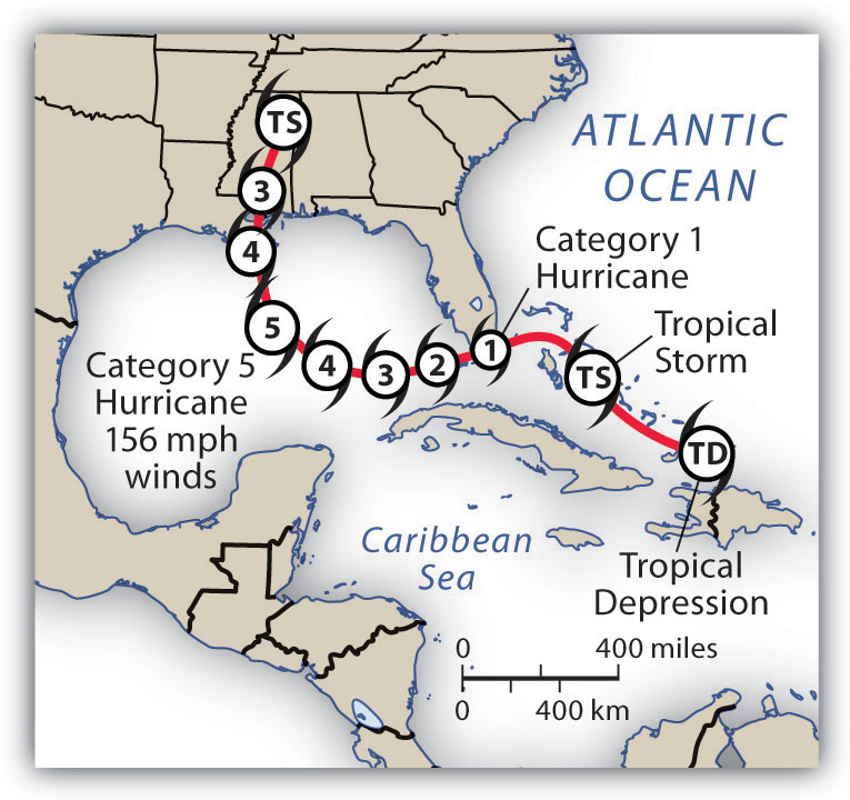
Hurricanes start as tropical depressions: storms with wind speeds between twenty-five and thirty-eight miles per hour. Cyclonic motion and warm temperatures feed the system. If a storm reaches sustained winds of thirty-nine to seventy-three miles per hour, it is upgraded to a tropical storm. Tropical depressions are numbered; tropical storms are named. When winds reach a sustained speed of seventy-four miles per hour, a storm is classified as a hurricane.
Hurricane Dynamics
Hot air rises. A water temperature of at least 80 degrees Fahrenheit sustains rising air in the development of a tropical depression. These storms continue to be driven by the release of the latent heat of condensation, which occurs when moist air is carried upward, and its water vapor condenses. This heat is distributed within the storm to energize it. As the system ga4ins strength, a full-scale hurricane can develop. Rising warm air creates a low-pressure area that draws in air from the surface. This action pushes water toward the center, creating what is called a storm surge. Storm surges can average five to twenty feet or more depending on the category of the hurricane. Cyclonic rotation is created by the rotation of the earth in a process called the Coriolis effect. The Coriolis effect is less prominent along the equator, so tropical cyclones usually do not develop within five degrees north or south of the equator.
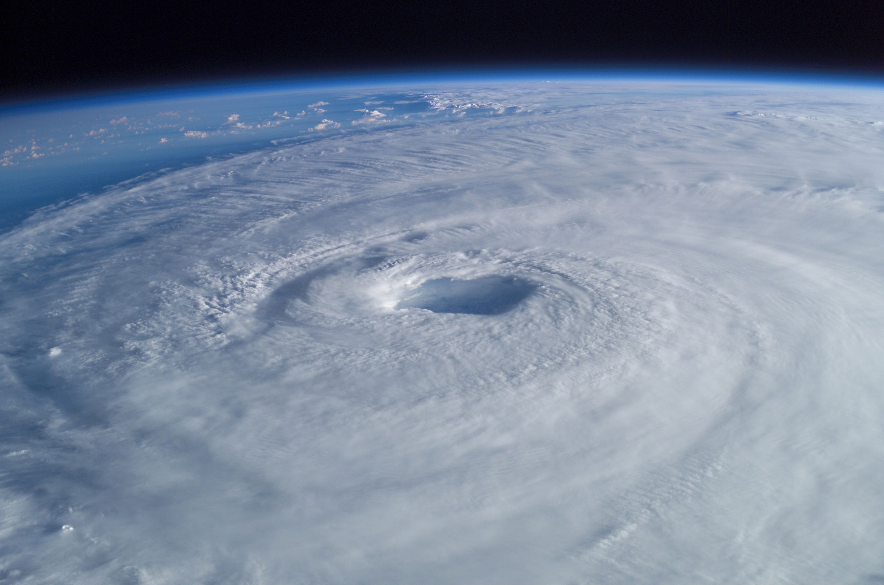
When a hurricane makes landfall (comes ashore), the storm surge causes extensive flooding. More people are killed by flooding because of the storm surge than by any other hurricane effect. At the center of the cyclonic system is the hurricane’s eye, where there is a downdraft of sinking air, but the wind is calm, and there are no clouds. The eye can extend from one to one hundred miles or more. Many people who have been in the eye of the hurricane believe the storm has passed, but in reality, they are in the center of it.
Bordering the eye of a storm is the eyewall, where the strongest winds and most torrential rainfall are found. This is the most violent part of the hurricane. Beyond the eyewall are feeder bands, with thunderstorms and rain showers that spiral inward toward the eyewall. Feeder bands can extend out for many miles and increase as the heat engine feeds the storm. Hurricanes lose their energy when they move over land because of the lack of heat generation. Once on land, the storm system breaks down. Rainfall and winds can continue, but with decreased intensity.
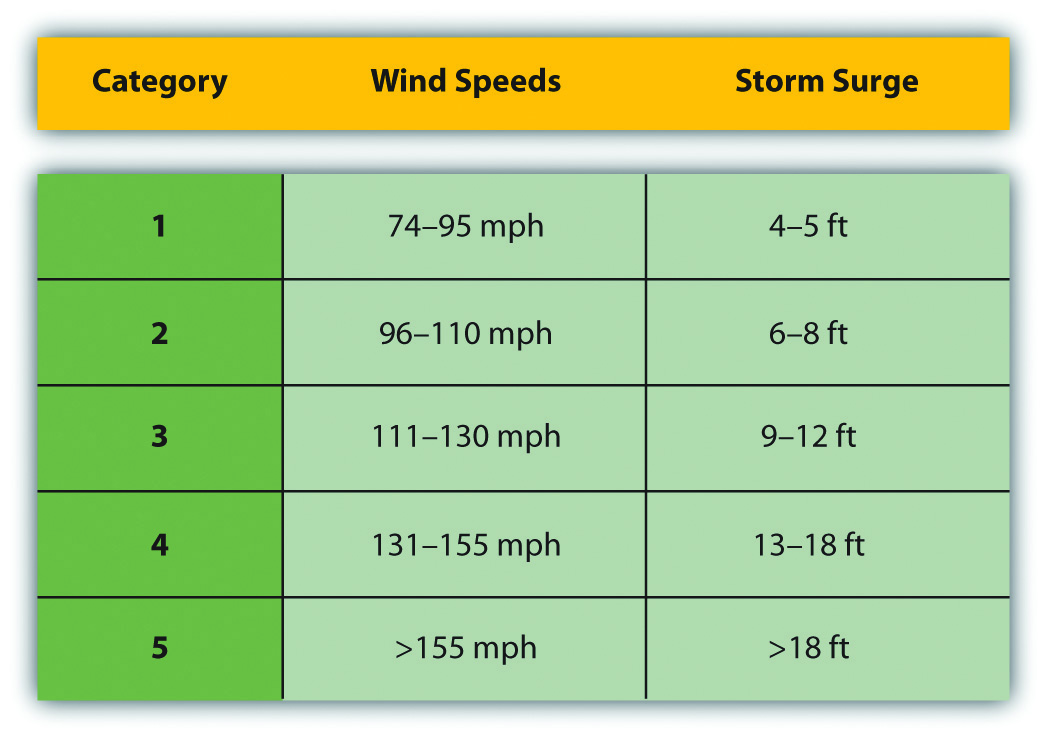
 Centuries ago, the Spanish used the term hurakan, an indigenous word for “evil spirits” or “devil wind,” to name the storms that sank their ships in the Caribbean. Hurricanes are rated according to sustained wind speed using the Saffir-Simpson Scale. This scale rates a hurricane according to five categories. Category 1 hurricanes have sustained wind speeds of at least seventy-four miles per hour and can inflict substantial damage to buildings, roofs, windows, and the environment. Category 5 hurricanes have sustained winds of more than 155 miles per hour and destroy everything in their paths. Hurricanes can also spawn tornadoes, which increase their potential for destruction.
 Annually, more than one hundred tropical disturbances develop in the North Atlantic, but only about ten make it to a tropical storm status, and five to six become hurricanes. Only two or three hit the United States in a typical year. Hurricane season for the North Atlantic lasts from June 1 to November 30. Tropical cyclones develop during the warmest season of the year when the water temperature is the highest. Though these weather patterns can bring enormous devastation to the landscape, they also redistribute moisture in the form of rain and help regulate global temperatures.
 Hurricane Camille was the strongest US hurricane on record at landfall, with sustained winds of 190 miles per hour and wind gusts of up to 210 miles per hour. Camille hit the US Mississippi coast in 1969 as a Category 5 hurricane. It devastated everything in its path, killing 259 people. Hurricane Katrina in 2005 was one of the most costly storms to impact the United States. Katrina started as a tropical depression while in the Bahamas. The storm reached a Category 5 hurricane as it passed through the Gulf of Mexico but diminished in strength when making landfall in Louisiana, with sustained winds of 125 miles per hour (a strong Category 3 hurricane). Katrina caused widespread devastation along the central Gulf Coast and devastated the city of New Orleans. At least 1,836 people lost their lives, and the cleanup cost an estimated $100 billion.
Since records were started in 1851 for hurricanes in the Atlantic Basin, there have been thirty-two hurricanes that reached category 5 in the region. A few of them have reached the Central American coast. Hurricane Mitch hit the coast of Central America in 1998 and dumped over seventy-five inches of rain across the countries of Honduras, El Salvador, Nicaragua, and Guatemala. Devastating winds and heavy rain caused the deaths of up to twenty thousand people. Destructive Category 5 hurricanes Edith and Felix made landfall in Nicaragua in 1971 and 2007, respectively. The Yucatán Peninsula and the coast of Mexico have also witnessed several devastating Category 5 hurricanes.
The Caribbean Basin is located in the path of many hurricanes developing out of the Cape Verde region of the North Atlantic. For example, 2008 was a particularly devastating hurricane season, with sixteen tropical storms and eight full-scale hurricanes, five of which caused massive devastation. Three Category 4 hurricanes (Ike, Gustav, and Paloma) cut through the northern Caribbean to hit the Greater Antilles. The most devastating was Ike, which ripped through the Caribbean, across the entire length of Cuba, and then on to the Gulf Coast of Louisiana and Texas. Ike’s immense size contributed to the fact that it was the third most costly hurricane on record. Ike caused an estimated $7.3 billion in damage to Cuba and more than $29 billion in damage in the United States. Hurricane Gustav made landfall in Hispaniola and Jamaica before increasing in strength and causing about $3.1 billion in damage to Cuba. In November of 2008, Hurricane Paloma made landfall in Cuba and caused an additional $300 million in damage to the island. Many of the other Caribbean islands were also devastated by the hurricanes that hit the region in 2008.
