Geography is the spatial study of the earth’s physical and cultural environments. Geographers study the earth’s physical characteristics, its inhabitants and cultures, phenomena such as climate, and the earth’s place within the universe. Geography also examines the spatial relationships between all physical and cultural phenomena in the world. Furthermore, geographers also look at how the earth, its climate, and its landscapes are changing due to cultural intervention. Geography is a much broader field than many people realize. Most people think of area studies as the whole of geography. In reality, geography is the study of the earth, including how human activity has changed it. Geography involves studies that are much broader than merely understanding the shape of the earth’s landforms. Physical geography involves all the planet’s physical systems. Human geography incorporates studies of human culture, spatial relationships, interactions between humans and the environment, and many other research areas that involve the different subspecialties of geography. Students interested in a career in geography would be well served to learn geospatial techniques and gain skills and experience in GIS and remote sensing, as they are the areas within geography where employment opportunities have grown the most over the past few decades.
Themes of Geography
Geography helps us make sense of the world through four historical traditions. Spatial analysis includes many of the concepts tied to geospatial technology: the study and analysis between the interactions and distribution patterns of the physical and human environments using spatial technology such as geographic information systems, satellite imagery, aerial photography and drones, global positioning systems, and more. Earth science includes the study of landforms, climates, and the distribution of plants and animals. Regional studies focus on a particular region to understand the dynamics of a specific interaction between human activity and the environment. Researchers studying human-landscape interaction examine the impact of humans on their landscape and find out how different cultures have used and changed their environments. Geography provides the tools to integrate knowledge from many disciplines into a usable form by providing a sense of place to natural or human events. Geography often explains why or how something occurs in a specific location. World geography utilizes the spatial approach to help understand the components of our global community.
The discipline of geography can be broken down into three fundamental areas of focus: physical geography, human geography, and world regional geography. These fundamental areas are similar in that they use a spatial perspective, and include the study of place and the comparison of one place with another.
Physical Geography
Physical geography is the spatial study of natural phenomena that make up the environment, such as rivers, mountains, landforms, weather, climate, soils, plants, and any other physical aspects of the earth’s surface. Physical geography focuses on geography as a form of earth science. It tends to emphasize the main physical parts of the earth—the lithosphere (surface layer), the atmosphere (air), the hydrosphere (water), and the biosphere (living organisms)—and the relationships between these parts.
Some researchers are environmental geographers, part of an emerging field that studies the spatial aspects and cultural perceptions of the natural environment. Environmental geography requires an understanding of both physical and human geography, as well as an understanding of how humans conceptualize their environment and the physical landscape.
The physical landscape is the term used to describe the natural terrain at any one place on the planet. The natural forces of erosion, weather, tectonic plate action, and water have formed the earth’s physical features. Many states and national parks in the United States attempt to preserve unique physical landscapes for the public to enjoy, such as Yellowstone, Yosemite, and the Grand Canyon.
Human Geography
Human geography is the study of human activity and its relationship to the earth’s surface. Human geographers examine the spatial distribution of human populations, religions, languages, ethnicities, political systems, economics, urban dynamics, and other components of human activity. They study patterns of interaction between human cultures and various environments and focus on the causes and consequences of human settlement and distribution over the landscape. While the economic and cultural aspects of humanity are the primary focus of human geography, these aspects cannot be understood without describing the landscape on which economic and cultural activities occur.
The cultural landscape is the term used to describe those parts of the earth’s surface that have been altered or created by humans. For example, the urban cultural landscape of a city may include buildings, streets, signs, parking lots, or vehicles, while the rural cultural landscape may include fields, orchards, fences, barns, or farmsteads. Cultural forces unique to a given place – such as religion, language, ethnicity, customs, or heritage – influence the cultural landscape of that place at a given time. The colors, sizes, and shapes of the cultural landscape usually symbolize some level of significance regarding societal norms. Spatial dynamics assist in identifying and evaluating cultural differences between places.
World Regional Geography
World regional geography studies various world regions as they compare with the rest of the world. Factors for comparison include both the physical and the cultural landscape. The main questions are, Who lives there? What are their lives like? What do they do for a living? Physical factors of significance can include location, climate type, and terrain. Human factors include cultural traditions, ethnicity, language, religion, economics, and politics.
World regional geography focuses on regions of various sizes across the earth’s landscape and aspires to understand the unique character of regions in terms of their natural and cultural attributes. Spatial studies can play an essential role in regional geography. The scientific approach can focus on the distribution of cultural and natural phenomena within regions as delimited by various natural and cultural factors. The focus is on the spatial relationships within any field of study, such as regional economics, resource management, regional planning, and landscape ecology.
The regions studied in world regional geography can be combined into more substantial portions called realms. Realms are large areas of the planet, usually, with multiple regions, that share the same general geographic location. Regions are cohesive areas within each realm. The following eleven realms are outlined in this text (click on the links to view them in Google Maps:
- Europe (Eastern Europe and Western Europe)
- The Russian Realm (Russian republic of the former Soviet Union)
- North America (United States and Canada)
- Middle America (Caribbean, Mexico, Central America)
- South America
- North Africa and Northwest Asia (also known as the Middle East)
- Subsaharan Africa (Africa south of the Sahara Desert)
- Southern Asia (India and its neighbors)
- East Asia (China, Mongolia, Japan, and the Koreas)
- Southeast Asia (mainland region and the islands region)
- Australia and the Pacific (including New Zealand)
Regions in Geography
A region is a basic unit of study in geography – a unit of space characterized by a feature such as a common government, language, political situation, or landform. A region can be a formal country governed by political boundaries, such as France or Canada; a region can be defined by a landform, such as the drainage basin of all the water that flows into the Mississippi River; and a region can even be defined by the area served by a shopping mall. Cultural regions can be defined by similarities in human activities, traditions, or cultural attributes. Geographers use the regional unit to map features of particular interest, and data can be compared between regions to help understand trends, identify patterns, or assist in explaining a particular phenomenon.
Regions are traditionally defined by inherent characteristics that provide a sense of place. Their boundaries vary with the type of region, whether it is formal, functional, or vernacular; each type has its meaning and defined purpose. A formal region has a governmental, administrative, or political boundary and can have political as well as geographic boundaries that are not open to dispute or debate. Formal boundaries can separate states, provinces, or countries from one another. Physical regions can be included within formal boundaries, such as the Rocky Mountains or New England. An official boundary, such as the boundary of a national park, can be considered a formal boundary. School districts, cities, and county governments have formal boundaries.
Natural physical geographic features have a significant influence on where the political boundaries of formal regions are set. If we look at a world map, we will recognize that many political boundaries are natural features, such as rivers, mountain ranges, and large lakes. For example, the Rio Grande makes up a portion of the border between the United States and Mexico. Likewise, between Canada and the United States, a significant part of the eastern border is along the Saint Lawrence Seaway and the Great Lakes. Alpine mountain ranges in Europe create borders, such as the boundary between Switzerland and Italy.
While geographic features can serve as convenient formal borders, political disputes will often flare up in adjacent areas, mainly if valuable natural or cultural resources are found within the geographic features. Oil drilling near the coast of a sovereign country, for example, can cause a dispute between countries about which one has dominion over the oil resources. The exploitation of offshore fisheries can also be disputed.
Functional regions have boundaries related to a practical function within a given area. When the function of an area ends, the functional region ends, and its boundaries cease to exist. For example, a functional region can be defined by a newspaper service or delivery area. If the newspaper goes bankrupt, the functional region no longer exists. Church parishes, shopping malls, and business service areas are other examples of functional regions. They function to serve a region and may have established boundaries for limits of the area to which they will provide service. An example of a common service area, a functional region, is the region to which a local pizza shop will deliver.
Vernacular regions have loosely defined boundaries based on people’s perceptions or thoughts. Vernacular regions can be fluid – that is, different people may have different opinions about the limits of the regions. Vernacular regions include concepts such as the region called the “Middle East.” Many people have a rough idea of the Middle East’s location but do not know which countries make up the Middle East. Also, in the United States, the terms Midwest or South have many variations. Each individual might have a different idea about the location of the boundaries of the South or the Midwest. Whether the state of Kentucky belongs in the Midwest or the South might be a matter of individual perception.
Similarly, various regions of the United States have been referred to as the Rust Belt, Sun Belt, or Bible Belt without a clear definition of their boundaries. The limit of a vernacular area is more a matter of perception than of any formally agreed-upon criteria. Nevertheless, most people would recognize the general area being discussed using one of the vernacular terms in a conversation.
Geospatial Technology
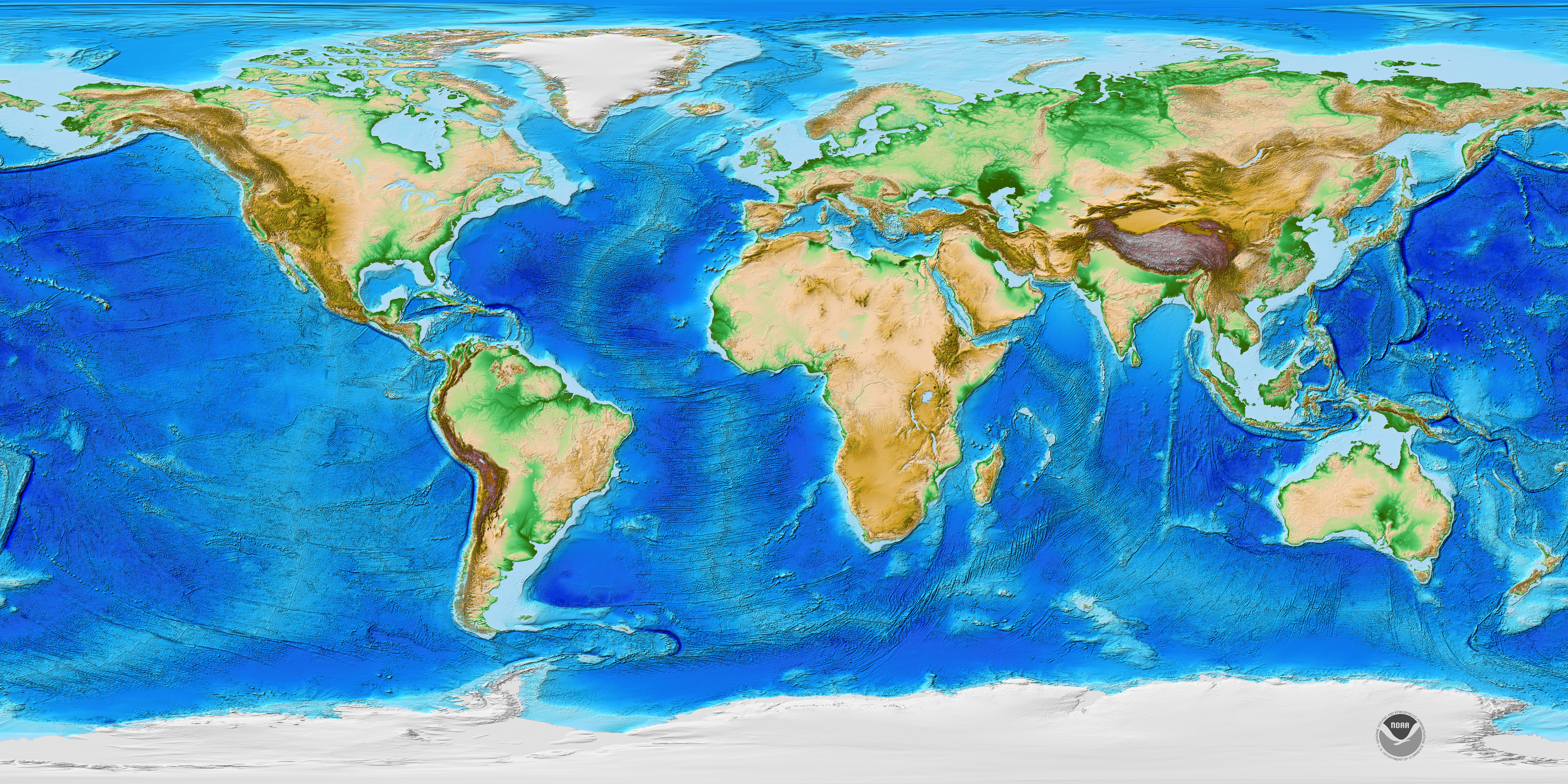
Traditionally, the field of cartography, or mapmaking, has been a vital discipline for geographers. While cartography continues to be an essential part of geography, geographers also look at spatial (space) and temporal (time) relationships between many types of data, including physical landscape types, economies, and human activity. Geography also examines the relationships between and the processes of humans and their physical and cultural environments. Because maps are powerful visual graphics tools that allow us to illustrate relationships and processes at work in the world, cartography and geographic information systems have become prominent in modern sciences. Maps are the most common method of illustrating different spatial qualities, and geographers create and use maps to communicate spatial data about the earth’s surface.
Geospatial techniques are tools used by geographers to illustrate, manage, and manipulate spatial data. Cartography is the art and science of making maps, which illustrate data in a spatial form and are invaluable in understanding what is going on at a given place at a given time.
Global Positioning Systems
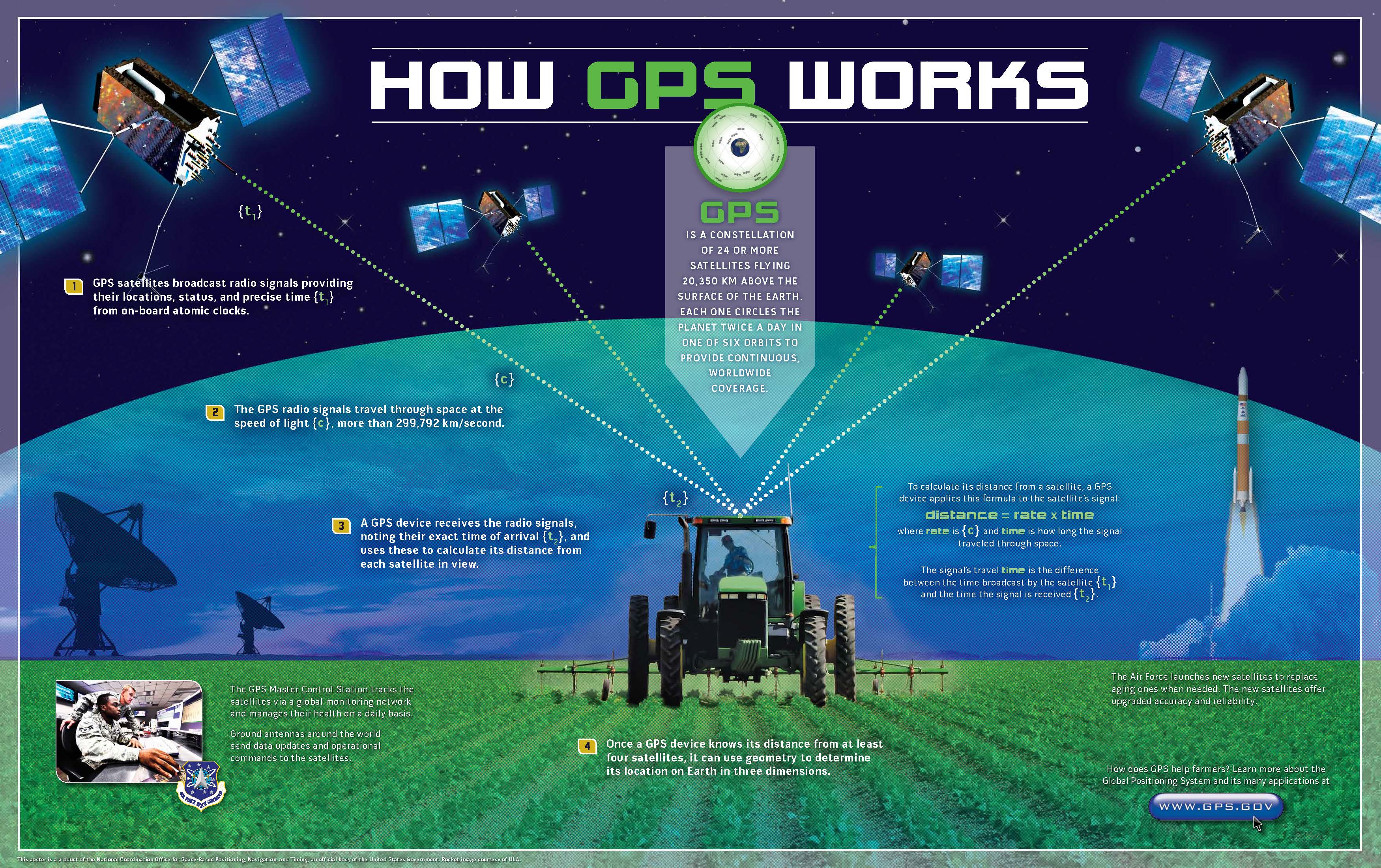
Making maps and verifying a location has become more exact with the development of the global positioning system (GPS). A GPS unit can receive signals from orbiting satellites and calculate an exact location in latitude and longitude, which helps determine where one is located on the earth or for verifying a point on a map. GPS units are standard equipment for many transportation systems and have found their way into products such as cell phones, handheld computers, fish finders, and other mobile equipment. GPS technology is widely implemented in the transport of people, goods, and services around the world.
Remote Sensing
Remote sensing technology acquires data about the earth’s surface through aerial photographs taken from airplanes or images created from satellites orbiting the earth. Remotely sensed images allow geographers to identify, understand, or explain a particular landscape or determine the land use of a place. These images can serve as essential components in the cartographic (map-making) process. These technologies provide the means to examine and analyze changes on the earth’s surface caused by natural or human forces. Google Earth is an excellent example of a computer tool that illustrates remotely sensed images of locations on the earth.
Geographic Information Systems
Geographic information systems (GIS), uses a computer program to assimilate and manage many layers of map data, which then provide specific information about a given place. GIS data are usually in digital form and arranged in layers. The GIS computer program can sort or analyze layers of data to illustrate a specific feature or activity. GIS programs are used in a wide range of applications, from determining the habitat range of a particular species of bird to mapping the hometowns of university students.
GIS specialists often create and analyze geographical information for government agencies or private businesses. They use computer programs to take raw data to develop the information these organizations need for making vital decisions. For example, in business applications, GIS can be used to determine a desirable location for a retail store based on the analysis of spatial data layers such as population distribution, highway or street arrangements, and the locations of similar stores or competitive establishments. GIS can integrate a number of maps into one to help analysts understand a place in relation to their own specific needs.
GIS also focuses on storing information about the earth (both cultural and natural) in computer databases that can be retrieved and displayed in the form of specialized maps for specific purposes or analyses. GIS specialists require knowledge about computer and database systems. Over the last two decades, GIS has revolutionized the field of cartography: nearly all cartography is now done with the assistance of GIS software. Additionally, the analysis of various cultural and natural phenomena through the use of GIS software and specialized maps is an integral part of urban planning and other social and physical sciences. GIS can also refer to techniques used to represent, analyze, and predict spatial relationships between different phenomena.
